| Example of Mesoscale Beta Elements | |
| Description | MCS Image |
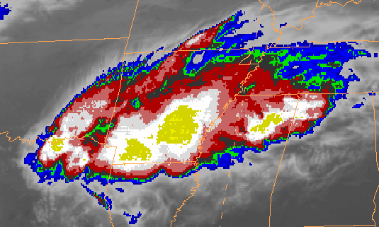
| Satellite Image 1145 UTC 10 May 2002 |
 |
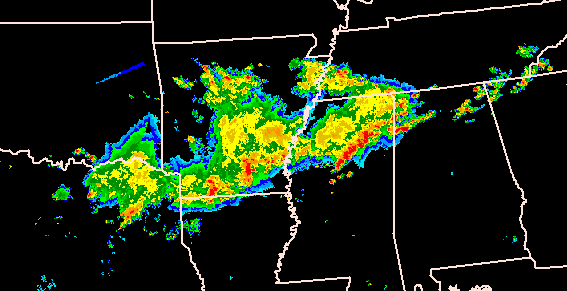
| Radar Image 1141 UTC 10 May 2002 |
 |
Mesoscale convective systems (MCS) are a frequent occurrence during the warmer half of the year when convection is the dominant precipitation producer. The movement of these convective clusters is often critical to a good forecast. The purpose of this web page is to discuss the motion of these systems. Mesoscale Convective Systems are discussed on another "Operational Weather Topic" page.
Individual thunderstorm cells tend to travel with the mean wind in the cloud bearing layer. Operationally, this motion can be approximated by the mean 700-500 mb wind. Severe thunderstorms frequently move to the right of the mean wind direction and slower than the mean wind speed. The movement of convective clusters as seen on satellite imagery have been observed to be both faster and slower than the mean wind speed. They typically travel to the right of the upper tropospheric wind direction.
We will define MCS propagation as the apparent movement of convective clusters as the result of preferred new cell development on one flank of the cluster. Individual cells within the cluster may still move with the mean wind but the cluster as an identifiable system moves with its own motion. Specifically, "satellite-observed MCS propagation refers to the translation of the most active convective portion of the MCS (the so-called meso-beta elements, MBEs) due to the formation, development, or merger of newly formed convective clusters" (Juying and Scofield 1989). This basis for determining MCS movement is preferred to movement of the satellite-based cloud-top centroid due to the tendency of the cloud-top to expand downwind. This downwind expansion is usually not in the same direction as the active cell formation.
| Example of Mesoscale Beta Elements | |
| Description | MCS Image |
| Satellite Image 1145 UTC 10 May 2002 |
 |
| Radar Image 1141 UTC 10 May 2002 |
 |
MBEs are best observed using a satellite loop where the active elements can be easily seen, usually as the colder cloud tops. Looking at a corresponding radar image can also help identify these elements. Compare the satellite and radar images in the above example and pick out the MBEs.
Propagation can be classified into four types (Juying and Scofield 1989):
Anticipation of backward, quasi-stationary, or regenerative propagation is important in flash flood situations. Let's review several research studies that have dealt with MCS movement and highlight some results with operational application.
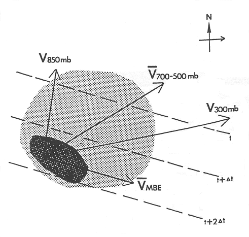
Merritt and Fritsch (1984) examined the MBEs embedded within some 100 mesoscale convective complexes (MCC) and MCC-like events from 1980 through 1984. They found that MBE movement was consistently to the right of the mean 850 to 300 mb wind direction and that MBEs (or MCSs in our phraseoloogy) tend to move along the 850-300 mb thickness contours. Merritt and Fritsch stated that "the speed of MBE movement appears to be modulated by the magnitude and relative position of lower tropospheric moisture convergence which in many cases can be inferred by the orientation of a low level jet feeding the MCC." The diagram below summarizes their results.
 |
|
Schematic hodograph showing the direction of MBE movement relative to an 850 mb and 300 mb wind, and a mean mid-tropospheric wind (700-500 mb layer). Dashed lines are 850-300 mb thickness contours. Light strippling is schematic cold-cloud shield of MCC; dark stippling is region of MBEs. [from Merritt and Fritsch 1984] |
These results provide a good estimate of the direction of MBE movement based on 850-300 mb thickness. Read on for other studies.
Juying and Scofield (1989) examined 38 warm-season MCSs that produced heavy precipitation during the period 1982 to 1987. They classified these systems into the four types noted above:
Eight of these systems transformed from backward to forward moving systems while four transformed in the other direction.
The tables below list the satellite, surface, and upper air features associated with the three types of propagation and the regenerative system. Comparison of fast forward, slow forward, and backward propagation shows differences in the location of colder IR tops, the presence of mergers, the location of the maximum 850 mb flow, and the MCS location relative to the strength of the upper level flow. Their results confirm that forward moving MCSs move parallet to the 850-300 mb thickness isopleths. This is the first study to indicate the importance of thickness diffluence to slow forward and backward propagating systems
| Slow Forward Propagation | Fast Forward Propagation |
| Regenerating MCSs | Backward Propagation |
Juying and Scofield (1989) summarize the environment associated with backward propagation of MCSs in the figures below. The first figure shows the favored area for backward propagating MCSs. The stippled area to the northwest of the theta-e ridge is where these systems occur and move toward the southwest. This is an area where the low level wind maximum advects the most unstable air into the new cell development region on the upstream side of the MCS.
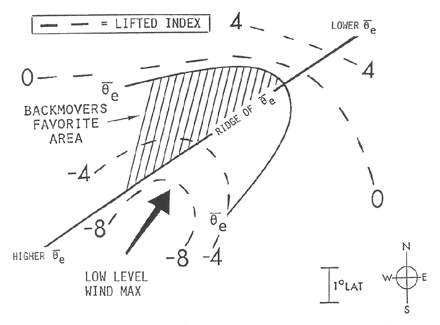 |
| Schematic of surface and upper air features associated with backward propagating MCSs. [Juying and Scofield 1989] |
The second figure shows a similar schematic with the addition of several features mentioned in the tables above. Of particular note is the backward propagation into the area of diffluent thickness.
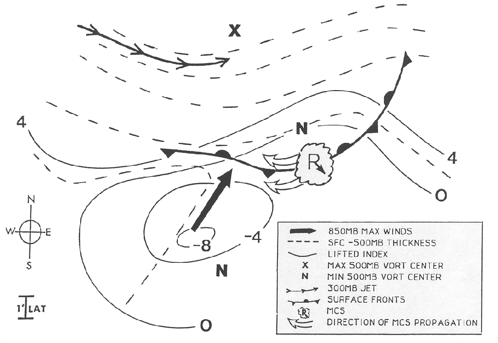 |
| Schematic of surface and upper air features assocaited with backward propagating MCSs; typical satellite features are also depicted. [Juying and Scofield 1989] |
Funk (1991) gives an overview of techniques used by the Forecast Branch of the National Meteorological Center (NMC, now NCEP) for heavy rainfall events produced by convection. He states that "warm-sector convection has been observed by NMC forecasters to develop frequently near or within a region when the 1000-500 mb thickness isopleths are diffluent." However, no specific comments by Funk relate MCS propagation to thickness diffluence.
A study of MCS propagation by Moore et al (1993) examined 33 MCS warm-season events from 1990 to 1992. They summarized the synoptic environment associated with MCS propagation as follows:
Backward propagating and quasi-stationary MCSs tend to occur where:
Forward propagating MCSs are most often found in environments where:
In essence these conditions suggest that the geographic relationship between the area favored for new cell development (in the traditional sense of moisture, instability, and lift (McNulty 1995)) and the MCS location determine the direction of propagation of the MCS. It is also easier to see how a forward propagating MCS, passing across a cell generation area, can change to a quasi-stationary or backward propagating system.
Using the above list of synoptic conditions from Moore et al (1993) and the location of traditional moisture, instability, and lift parameters, a forecaster should be able to identify the area around an existing MCS where new cell generation is most likely. This area will define the propagation direction for the next several hours.
Corfide et al (1996) examined 103 mesoscale convective systems, 99 of which met mesoscale convective complex criteria. They evaluated the conceptual model shown in the top portion of the figure below. This figure shows a vector relationship among MBE movement (forecast MCS motion vector in red), the mean flow in the cloud layer (850-300 mb), and propagation vector. This model assumes that the propagation vector is equal in magnitude and opposite in direction to the low level jet.
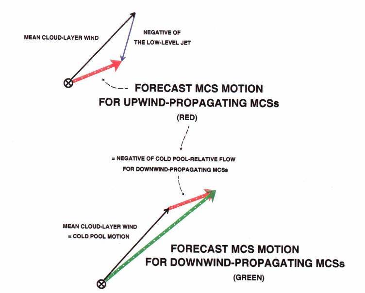 |
| top (Corfide et al 1996): conceptual model of MBE movement as the vector sum of the mean flow in the cloud layer and the propagation component whose magnitude and direction is assumed to be equal and opposite to those of the low level jet ; bottom (Corfidi 2003): revised MBE movement for forward propagating MCSs |
They tested this model by developing scatter plots for the following pairs of parameters:
Based on the last two scatter plots, the average absolute errors using this model were found to be +2.0 m/s and +17.2 degrees.
This study concluded that the procedure:
Corfidi (2003) revised this model for forward propagating MCSs using the vector representation in the bottom of the figure above. The forecast MCS motion vector (in red) is now added to the mean cloud layer flow vector to produce a new forecast motion vector (in green). For forward-propagating MCSs this revised procedure produces better results.
This module has defined MCS propagation in terms of the mesoscale beta elements viewable in satellite imagery. Results from several research studies on MCS propagation have also been described. These results will help you better anticipate the movement of MCSs. It should also be recognized that a working knowledge of forecast techniques for thunderstorm initiation can be very useful for anticipating changes in MCS location.
Corfidi, S.F., 2003: Cold pools and MCS propagation: Forecasting the motion of downwind-developing MSCs. Weather and Forecasting, 18, 997-1017.
Corfidi, S.F., J.H. Merritt, and J.M. Fritsch, 1996: Predicting the movement of mesoscale convective complexes. Weather and Forecasting, 11, 41-46.
Funk, T.W., 1991: Forecasting techniques utilized by the Forecast Branch of the National Meteorological Center during a major convective rainfall event. Weather and Forecasting, 6, 548-564.
Juying, X., and R.A. Scofield, 1989: Satellite-Dervied Rainfall Estimates and Propagation Characteristics Associated with Mesoscale Convective Systems (MCS). NOAA Technical Memorandum NESDIS 25, 49 pp.
McNulty, R.P., 1995: Severe and convective weather: A Central Region forecasting challenge. Weather and Forecasting, 10, 187-202.
Merritt, J.H., and J.M. Fritsch, 1984: On the movement of the heavy precipitation areas of mid-latitude mesoscale convective complexes. Preprints, 10th Conference on Weather Forecasting and Analysis, Clearwater Beach (AMS), 529-536.
Moore, J.T., C.H. Pappas, and F.H. Glass, 1993: Propagation characteristics of mesoscale convective systems. Preprints, 17th Conference on Severe Local Storms, St. Louis (AMS), 538-542.