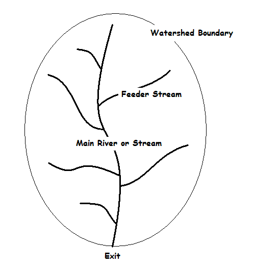
Example of a Watershed or Basin
Flash floods are one of the more dangerous weather-related phenomena in the United States. In addition to the physical damage caused by this type of flooding, more death are attributed to flash flooding than to other convective-related dangers, i.e., tornadoes and lightning.
The purpose of this web page is to provide a broad overview of flash flooding and the meteorological conditions that contribute to this danger. It is not intended as an in-depth discussion of this phenomenon.
A flash flood is a rapid rise in water level at some location over a short time period (on the order of minutes to hours). In other words, if you stood at the location where the flash flood was occurring, you could literally watch the water rise. However, don't stand there too long or you might very quickly be in trouble.
The National Weather Service issues flash flood warnings for water rises that result from three causes:
Although the latter two causes are important, this web page will focus on the first one and the hydrological and meteorological conditions associated with excessive rainfall.
In all three situations, water levels can rise rapidly by as much as 30 feet, although most rises are usually much less than that. This rapid rise in water does extensive damage and can kill people. The types of damage associated with flash floods include:
For flash floods to occur favorable hydrological and meteorological conditions must coexist in time and in space. Heavy rainfall is a necessary but not sufficient condition for the occurrence of flash floods. That is, you can have heavy rainfall but if the hydrological conditions for flooding are not present, the water not cause problems.
Please note that there is a difference between floods and flash floods. That difference involves the timing of the water rise. In flash floods, the water rises rapidly, usually in a matter of minutes to several hours. For floods, the water rise is much slower and often covers a much broader area.
Let's explore the hydrological and meteorological conditions associated with flash floods.
When rainfall hits the Earth's surface, one of three things happen:
From a flash flood perspective, the amount of surface runoff is critical. If there is a high volume of runoff over a short period of time for a particular area, a flash flood can occur.
Surface runoff refers to that water that flows downhill along the Earth's surface. For any given rainfall amount, the amount of runoff depends upon the ability of the surface to absorb water (infiltration capacity) and the holding capacity of depressions (lakes, ponds, ditches, etc.) in the drainage area. The latter is relatively small compared to the former.
In addition to the amount of rain that fall, the amount of surface runoff passing any given location during a specific time (and hence the flash flood potential) depends upon the physical characteristics of the basin or watershed that drain into that location. A watershed is defined as the land area that drains into a specific location. (See figure below.) It has explicit boundaries based on the local topography. A large watershed can be divided into smaller watersheds that define water flow at points within the larger watershed. When assessing the flash flood potential for a location, the first thing to examine is the watershed that drains surface runoff into that point.

The various features of a watershed that are important to flash flooding include:
Flash flooding is likely when the volume of water occurring over a watershen is large and occurs over a short period of time. This large volume of water drains through the watershed and affects the exit point of the watershed. One way of assessing the volume of water falling on the watershed is the average basin rainfall or ABR. The ABR defines the average depth of rainfall over the basin. If you know the area of the watershed, you can then calculate the volume of water that has fallen. In general, the ABR is proportional to the surface runoff and thus the volume of water passing the exit point of the watershed.
The physical characteristics of a watershed determine how fast the water that falls collects at the exit point of the watershed. These characteristics include:
Urban areas tend to be covered with roads, building and other surfaces impervious to water. This results in increased surface runoff compared to less urbanized areas. Thus, urban areas can collect large water volumes very quickly and create flash (or urban) flooding problems more easily than non-urban areas.
The infiltration of water into soil depends upon two factors: the soil type and the saturation of the soil.
Clay soils (low porosity) allows less infiltration than sand (high porosity). Rocky areas tend to have shallow soil depth and less infiltration compared to deeper soil layers. Although a smaller watershed may have some uniformity of soil type, larger basins will likely have a variety of soil types and infiltration rates. All these factors need to be considered when assessing surface runoff potential.
Soil cannot hold an infinite amount of water. At some point, soil becomes saturated and will not allow additional infiltration. For any given rainfall amount, when saturation occurs, surface runoff will increase as infiltration approaches zero. From a flash flood perspective, if recent rains have saturated the soil in a local area, additional rains, particularly if they are expected to produce heavy rainfall, significantly increase the amount of surface runoff and the potential for flash flooding.
The type and amount of ground cover impacts the amount of surface runoff. Vegetation tends to collect water on its leaves and foliage, slow down or inhibit surface runoff, and increase the time available for infiltration. When vegetation does not exist, as often occurs after large fires, surface runoff increases and flood problems increase.
Temperature impact soil infiltration. As a result, if the soil freezes during the winter, surface runoff increases.
Based on the overview provided above, it should be obvious that determining surface runoff at any given point is a very complex calculation that depends upon many variables. As a result, the National Weather Service River Forecast Centers (RFCs) use hydrologic models that take these variations into consideration. Everyday they take the daily rainfall, modify soil moisture, and calculate surface runoff into streams and rivers.
Part of this process is the production of flash flood indices that tell forecasters how much rain must fall into a watershed over a specified period (usually 3 hours) to produce flash flooding. If you know how much rain has fallen and the response time for a given watershed (which is based on the physical characteristics described above), you can determine the height and time of a potential flash flood. Determing the rainfall amount is the meteorological part of this challenge.
As noted above, for flash flooding to occur at a location there must be high rainfall rates over an extended period of time and hydrologic conditions that favor rapid runoff at that location. High rainfall rates are often associated with large mid-latitude cyclones, tropical cyclones, and deep moist convection (thunderstorms). Large areas of rainfall associated with the first two weather systems are easy to anticipate using numerical models. However, forecasting deep moist convection is a little more challenging.
To produce high rainfall rates at a location, thunderstorms affecting that area and producing significant rainfall usually fall into one of several categories:

In all cases, high rainfall rates must produce sufficient rainfall to surpass the minimum amount of water needed to produce rapid water rises in a watershed, i.e., flash flooding. Recognizing these situations is not always easy. In most situations this recognition involves the movement of thunderstorms cells and the availability of moisture to sustain the deep moisture convection.
Thunderstorm cells tend to move with the mean wind in the cloud bearing layer. If the winds in the mid and upper troposphere are weak, thunderstorms will move slowly or very little. If conditions are favorable for continued thunderstorm development (i.e., the presence of moisture, instability and a lifting mechanism), a cluster of storms (such as a mesoscale convective system or MCS) will persist over an area and increase the chance for flash flooding.
If the mean wind in the cloud bearing layer is parallel to a low level boundary (such as a stationary front or outflow boundary), thunderstorm cells will move along the front and repeatedly traverse the same area. If conditions along the front or boundary are favorable for continued thunderstorm development, storms can persist over an area for an extended period of time and increase the chance for flash flooding.
In areas of elevated terrain, low level forcing and weak upper winds can often combined to produce thunderstorms that appear anchored to the terrain. If these storms are producing significant rainfall, flash floods can result. An excellent example of this situation was the Big Thompson Canyon flash flood in the later 1970s.
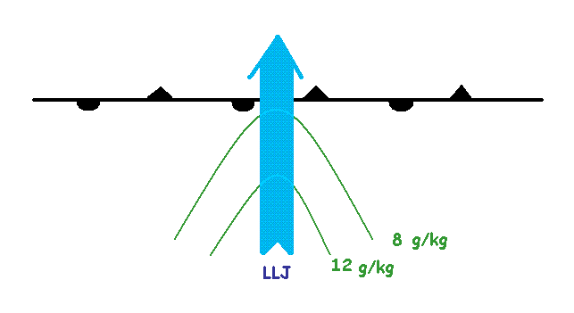
For a MCS to produce significant rainfall, its moisture must be continually replenished. This means that there must be a high moisture content through a deep layer of the atmosphere available to flow into the complex, i.e., a moisture source "to feed the mesoscale beast." A feature common to many flash flood situations is a low level jet (LLJ) flowing into a stationary boundary along a low level moist tongue. (See figure below.) This strong inflow of moist unstable air provides the fuel to keep the convection going as well as supplying the moisture needed to produce heavy rainfall.

The LLJ is a noctural phenomenom and is frequently a forcing mechanism for the occurrence of nighttime thunderstorms.
This web page has provided an overview of the conditions needed to produce flash flooding. Many of the inqredients occur frequently, but they need to occur at the same time and in the same place to produce flash flooding.
A significant amount of the material found on this web page is based on the article by Bob Davis (2001), listed below. It is highly recommended that you review this reference for a much more indepth knowledge of flash flood forecasting.
Davis, Robert S., 2001: Flash Flood Forecast and Detection Methods. (Article in: Severe Convective Storms, C.A.Doswell III, editor.) American Meteorological Society, pp. 481-525.